GEOSPATIAL INFORMATION SYSTEM
- Mapping My Journey
- Mapping My Journey
Geospatial Technology & Location Based Services:
Information services have evolved rapidly over the years and adding a new dimension to this is knowing where a person or an object is located. The union of GIS, Internet, wireless communication, location finding
techniques and mobile devices have given rise to the exciting Location based services making a major impact on the way navigation is done and businesses are conducted. The evolution has just began and throws open many opportunities for technologies and businesses to take advantage of it.
Trying to find out location has been of prime importance to man who adopted various methods to accomplish it. Man has used stars, landmarks and verbal queries since ancient times to find out his location. The middle ages had man using compass and maps to find his location. With advent and growth of technology the need was felt was more sophisticated devices to find location and in a natural flow of sequences man started thinking of ways to use this location finding techniques for his commercial and social benefits.
What is LBS?
We could begin by getting a feel of what is Location Based Service or LBS. It is the capability to find the geographical location of the mobile device and then provide services based on this location information. This would mean a person asking for information about the nearest ATM outlet based on his location in the city, which is within his reach. Thus we could say that Location based services deliver geographic information between mobile and/or static users via the Internet and/or wireless network.
This seems rather an exciting prospect, which could generate mass enthusiasm and could appeal to many prospective users and developers. LBS promises to facilitate the delivery of spatial data along with providing routing and direction-finding information. According to a poll by Integrated Data Communications, Inc. (IDC), two-thirds of Americans want wireless location-based services, with safety and security issues (emergency call, roadside assistance, and driving directions) as the primary reasons for wanting location-based services. Prospective users are even ready to pay premium or even accept advertising on their devices for the services.
The applications of LBS could be varied and innovating. Services that exploit the users location could be wide spread in the years to come. The service providers could move or have moved into areas like providing services incase of emergencies, route finding and many more limited only by mans imagination. There are definitely challenges for this market, which include figuring out what applications to develop, how to generate revenue from the applications, overcoming consumer acceptance hurdles and how to protect user privacy. Nonetheless the concern of this paper is not to indulge in the future of these applications but discover the technical aspects to LBS.
The Ingredients
The impetus to Location Based Services was given by the Federal Communications Commission of US (www.fcc.gov) ruling, which required the network operators to provide emergency services by locating the user of the mobile device within 125 meters. It required wireless network operators to supply public emergency services with the caller’s location and callback phone number. This hastened the emergence of new and dynamic field called LBS, where the service was based on the geographical location of the calling device. Further, the developments in the field of Positioning Systems, Communications and GIS, fueled the imagination of the industry people with regards to the LBS. This ability to provide the user a customized service depending upon his geographical location could be used by telecommunication companies to restaurant owners.
A successful LBS technology must meet the position accuracy requirements determined by the respective service, at the lowest possible cost and with minimal impact on network and the equipment. The obvious technology needed in providing LBS is getting to know the location or the position, the geographic data of that location and an application to process the position information along with the geographic data to provide Location Based Service. So we could consider the ingredients needed for LBS as
One of the most obvious and important ingredients behind LBS is positioning recognized system).
There are various means of determining positioning.
Manual methods have been in use to rely the location of the user like the emergency response services such as E-911 centers or American Automobile Association’s (AAA) roadside assistance service. These services were and are used by drivers to seek services like roadside assistance, navigation and routing after explicitly conveying the location.
With the convergence of wireless communications and the Internet, the term location services has taken on a new meaning and has captured our attention as the next big technology advancement that will impact our lives, even more than the wired Internet has. This emerging industry will bring wireless location services to market.
Network Based positioning
Finding the location of a mobile device in relation to its cell site is another way to find out the location of an object or a person. Various methods are adopted to determine the location of the mobile user.
Network based positioning relies on various means of triangulation of the signal from cell sites serving a mobile phone.
The geographical position of the device is found out through various techniques like
techniques and mobile devices have given rise to the exciting Location based services making a major impact on the way navigation is done and businesses are conducted. The evolution has just began and throws open many opportunities for technologies and businesses to take advantage of it.
Trying to find out location has been of prime importance to man who adopted various methods to accomplish it. Man has used stars, landmarks and verbal queries since ancient times to find out his location. The middle ages had man using compass and maps to find his location. With advent and growth of technology the need was felt was more sophisticated devices to find location and in a natural flow of sequences man started thinking of ways to use this location finding techniques for his commercial and social benefits.
What is LBS?
We could begin by getting a feel of what is Location Based Service or LBS. It is the capability to find the geographical location of the mobile device and then provide services based on this location information. This would mean a person asking for information about the nearest ATM outlet based on his location in the city, which is within his reach. Thus we could say that Location based services deliver geographic information between mobile and/or static users via the Internet and/or wireless network.
This seems rather an exciting prospect, which could generate mass enthusiasm and could appeal to many prospective users and developers. LBS promises to facilitate the delivery of spatial data along with providing routing and direction-finding information. According to a poll by Integrated Data Communications, Inc. (IDC), two-thirds of Americans want wireless location-based services, with safety and security issues (emergency call, roadside assistance, and driving directions) as the primary reasons for wanting location-based services. Prospective users are even ready to pay premium or even accept advertising on their devices for the services.
The applications of LBS could be varied and innovating. Services that exploit the users location could be wide spread in the years to come. The service providers could move or have moved into areas like providing services incase of emergencies, route finding and many more limited only by mans imagination. There are definitely challenges for this market, which include figuring out what applications to develop, how to generate revenue from the applications, overcoming consumer acceptance hurdles and how to protect user privacy. Nonetheless the concern of this paper is not to indulge in the future of these applications but discover the technical aspects to LBS.
The Ingredients
The impetus to Location Based Services was given by the Federal Communications Commission of US (www.fcc.gov) ruling, which required the network operators to provide emergency services by locating the user of the mobile device within 125 meters. It required wireless network operators to supply public emergency services with the caller’s location and callback phone number. This hastened the emergence of new and dynamic field called LBS, where the service was based on the geographical location of the calling device. Further, the developments in the field of Positioning Systems, Communications and GIS, fueled the imagination of the industry people with regards to the LBS. This ability to provide the user a customized service depending upon his geographical location could be used by telecommunication companies to restaurant owners.
A successful LBS technology must meet the position accuracy requirements determined by the respective service, at the lowest possible cost and with minimal impact on network and the equipment. The obvious technology needed in providing LBS is getting to know the location or the position, the geographic data of that location and an application to process the position information along with the geographic data to provide Location Based Service. So we could consider the ingredients needed for LBS as
- Location or positioning
- Geographic data
- Control Center
- Communication System
One of the most obvious and important ingredients behind LBS is positioning recognized system).
There are various means of determining positioning.
- Manual
- Network Based Positioning
- GPS
Manual methods have been in use to rely the location of the user like the emergency response services such as E-911 centers or American Automobile Association’s (AAA) roadside assistance service. These services were and are used by drivers to seek services like roadside assistance, navigation and routing after explicitly conveying the location.
With the convergence of wireless communications and the Internet, the term location services has taken on a new meaning and has captured our attention as the next big technology advancement that will impact our lives, even more than the wired Internet has. This emerging industry will bring wireless location services to market.
Network Based positioning
Finding the location of a mobile device in relation to its cell site is another way to find out the location of an object or a person. Various methods are adopted to determine the location of the mobile user.
Network based positioning relies on various means of triangulation of the signal from cell sites serving a mobile phone.
The geographical position of the device is found out through various techniques like
- Cell of Origin
- Time of Arrival
- Angle of Arrival
- Enhanced Observed Time Difference
- Assisted GPS
Cell of Origin (COO)
This is the most natural way to start offering LBS because all handsets support this technology. COO uses the network base station cell area to identify the location of the caller. The accuracy depends upon the cell area and the accuracy can be up to 150 meters for an urban area. Although the accuracy is not high and cannot be applied for emergency usage it is popular amongst the operators, as it does not require any modifications in the handset or the network, hence it is comparatively cheap to deploy.
Time of Arrival (TOA)
Here the difference in the time of arrival of the signal from the mobile to more than one base station is used to calculate the location of the device. The cost benefit analysis is not very much in favor of the usage of this technology, as the cost of implementing this is very high as compared to the enhancement in the performance. It is expensive because of the large number of location measurement units (LMUs) required. The accuracy of TOA is definitely better than COO but again it is dependent on the visibility of the terminal transmissions at LMU sites.
Angle of Arrival (AOA)
AOA is a system that calculates the angles at which a signal arrives at two base stations from a handset, using triangulation to find location. AOA works poorly in urban settings, where buildings interrupt signals.
Enhanced Observed Time Difference
Enhanced Observed Time Difference (E-OTD) systems operate by placing location receivers, overlaid on the cellular network as a location measurement unit (LMU) at multiple sites geographically dispersed in a wide area. This is the most accurate technique but subject to the visibility of the base stations. The technique is subject to degradation in places like buildings. In fact any geographical hindrance that affects the signal will result in reduced accuracy.
Assisted GPS (AGPS)
The last main category assisted global positioning services (AGPS) is an amalgamation of mobile technologies and GPS. AGPS can be accurate up to ten meters, but is expensive for the end-user, as they would have to invest in a GPS-equipped handset. Besides this, GPS handset necessarily needs to be in sight of three or more satellites, hence making it’s implementation difficult in built areas and more so from indoor, where people spend a significant portion of their time. A-GPS can help to provide rich services to the users like self-navigation and emergency services because of its accuracy.
Cell of Origin is most accepted technology used by cell network operators to find out location of the mobile device as it serves the purpose and requires minimum investment. The next step in this direction could be E-OTD for better accuracy but with SW modifications in the mobile terminals. The third step could be A-GPS capability with SW and HW modifications in mobile terminals.
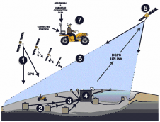
GPS
Navigation and positioning are critical to so many activities and yet the methods have always been quite cumbersome. Over the years all kinds of technologies have tried to simplify the task but every one has had some disadvantages.
The Global Positioning System a gift of the arms race has changed navigation and position forever.
GPS is a worldwide radio navigation system consisting of 24 satellites and their ground stations. Imagine the world divided into square meters with its unique address so we can literally point each location on the earth.
The miracle here is the GPS receiver, which have now been miniaturized to just a few integrated circuits and are economical. The principals of GPS are quite simplistic in nature, yet this simple solution to maintaining knowledge of the exact location of a vehicle or troop of vehicles is currently being trusted by such relentless industries as Police Forces, Hospitals and Fire Departments. Other industries such as Taxi Cab Companies, Messenger Services, Cement and Concrete suppliers, Construction Firms and Utility Companies have also discovered the benefits of GPS, and they are finding advantageous and profitable results as an outcome.
GPS is based on the concept of Trilateration. Trilateration is a basic geometric principle that allows you to find one location if you know its distance from other, already known locations.
Trilateration is at the very root of GPS. No fewer than 5 satellites are in view of any given spot on the Earth’s surface at any given moment. In order to use the formula of trilateration it is only necessary for three signals to be intercepted by a GPS receiver. Using the information the satellites transmit to the receiver and by calculating the time the signal took to reach the receiver, the receiver is able to recognize its exact distance from the satellite. By collecting signals from three of more satellites in carefully monitored orbit the receiver computes its own spatial relationship to each satellite in order to come up with a precise reading of its position on the planet.
Thus for a GPS receiver to find your location, it has to determine two things:- The location of at least three satellites above you
- The distance between you and each of those satellites
The next ingredient is the GIS data needed to facilitate LBS. It provides the data to render man made structures like road network, geocoded customer addresses and buildings and terrains like mountains and rivers. GIS is also used to manage point-of-interest data such as location of gas stations, restaurants, cinema halls, etc. Finally, GIS information also includes information about the radio frequency characteristics of the mobile network. This allows the system to determine the serving cell site of the user or the wireless serving boundaries.
The intensity or quality of GIS data needed is dependent in the type of service to be provided to the user. A service that determines navigation or pin pointing the ATM center requires a database of rich GIS data. If a sophisticated system were to set up in a developing nation it would not be wrong to say, how can one do this? The data infrastructure in these countries is still infantile. These data are either unknown or is inaccessible to potential users, in and outside the government. Data availability, accessibility, quality, documentation and dissemination are critical issues. Thus the non-availability of correct and extensive GIS data often makes implementation of not only something like a Navigation system difficult but various Disaster management based services are also hampered.
The GIS data needed should be updated and rich to be able to cater to various demands of LBS.
Control Center
The control center is another important element in LBS. It is the center of data management and dissemination of location services. The location data, geocoded data or map data need to be managed and manipulated to provide the various services based on the location to the user.
Retrieving and using Geocoding is of prime importance as it determines the latitude and longitude of an address. The technical requirements of geocoding services can vary from trivial to demanding. A trivial approach could mean getting the approximate location of an address in a street network.
Sophisticated mapping is needed to visualize location related data. Mapping requires spatial queries and visual algorithms. These operations require good geographic data. Sophisticated algorithm is again required for routing and navigation services. The applications need to scalable and robust to enable prompt and perfect services.
The control centers and the intensity of the work they perform are again dependent on the scale of user service provided by them.
Communication system
It is inevitable that communication plays a vital role in LBS. Messaging is required to convey the location to the control center and provide the service needed. The system could be based on various options like:- Radio with dedicated channels
- Cellular telephony (SMS)
- Satellite communications (GSM)
While the ingredients are very much in place it is time to ponder whether all the ingredients are necessary for LBS. The needs of various kinds of location services provided could vary and so could vary the technology used or the ingredients. When choosing the most suitable technology the LBS providers need to categorize the application, service and customer segments.
LBS has made foray into the market. Attractive location-based services covering all walks of life are here to stay hampered only by mans imaginative limits. We must, however, understand that there is no single universal solution to LBS. Positioning accuracy, service requirements and infrastructure greatly determine the ingredients.
